
With increasingly more access to very high-resolution Earth observation data, analysts, operators and commanders are equipped with trusted visual confirmation of activity across borders, infrastructure, logistics corridors and contested environments.
But modern Intelligence, Surveillance and Reconnaissance (ISR) missions rarely stop at “What can we see?”
More harder questions often come next:
- How is the terrain shaped?
- Where are the approaches constrained?
- What is exposed, concealed or elevated?
- How has a facility changed in ways that affect access, targeting, force protection or damage assessment?
- What must we understand about the physical environment before we send boots on the ground?
Being equipped with the operational context to confidently answer these questions is where multi-frame stereo imaging extends the value of space-based intelligence. It moves very high-resolution satellite imagery from visual confirmation to measurable intelligence of the operational environment.
The strategic value of stereo imaging
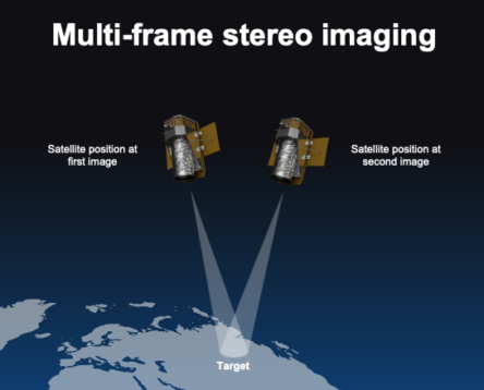
Stereo imaging is a geospatial sensing method in which two or more images of the same target are captured from different viewing angles during the same collection sequence.
Because each frame observes the target from a different angle, the resulting image set can support 3D understanding, height extraction, terrain analysis, structure assessment and derivative geospatial products such as digital surface models and digital elevation models.
BlackSky offers two types of 35 cm stereo imaging: 2-frame Stereo Pair and 5-frame Stereo Set.
2-frame stereo pair
2-frame stereo imaging is the focused dimensional intelligence layer. Traditional 2-frame stereo pair consist of two images of the same target from two different angles, ranging between 10 and 50 degrees. It is well-suited for collections where teams need to assess access, elevation, structure and surrounding terrain with efficient 3D context without overbuilding the collection requirement.
Its value is speed-to-context.
2-frame stereo imaging gives mission teams the dimensional insight needed to improve planning and interpretation while preserving collection agility.
- Planners can better understand slope and access around a route
- Analysts can assess the height and shape of key structures
- Damage assessment reports can include physical context to visible change
- Border security agents can more confidently understand how terrain affects movement, observation and concealment
The mission advantage of 2-frame stereo imaging is focused measurability. It helps convert high-resolution imagery from “we can see it” to “we can measure and interpret it.”
5-frame stereo set
5-frame stereo is the higher-confidence characterization layer. It expands on the traditional stereo model by collecting a set of five images over the same target from different viewing angles in a single satellite pass. This creates richer dataset of details to support more robust 3D reconstruction and interpretation in complex terrain, dense infrastructure or high-consequence operational environments.
Its value is confidence in complexity.
5-frame stereo imaging helps reduce ambiguity when the mission requires detailed physical characterization about specific features, not just the terrain around them.
- Analysts can derive structural deformation, crater depth, debris patterns and changes to surface elevation
- Operators can better determine whether a facility has vertical complexity or a target area includes terrain masking
- Planners can better assess the structure, height, rooflines, walls and surrounding physical relationships in urban environments
The mission advantage of 5-frame stereo imaging is not just more images. It’s more defensible, measurable intelligence of an operational environment. It helps teams resolve more complex questions with greater assurance.
Why modern ISR needs stereo imaging
The combined value of BlackSky’s very high-resolution 35 cm single-frame and multi-frame stereo imaging capabilities is powerful.
- Single-frame imagery helps teams detect, confirm, persistently monitor and make informed decisions quickly.
- 2-frame stereo pair imagery helps teams efficiently understand dimensional context.
- 5-frame stereo set imagery helps team characterize complex environments with feature-level intelligence.
Together, these imaging capabilities create a layered ISR model that help analysts quantify the physical battlespace faster and equip commanders with a deeper understanding of the operational environment needed to set an effective course of action and ensure mission success.
To learn more about BlackSky’s multi-frame stereo imaging and complete suite of mission advantage solutions, contact us today.