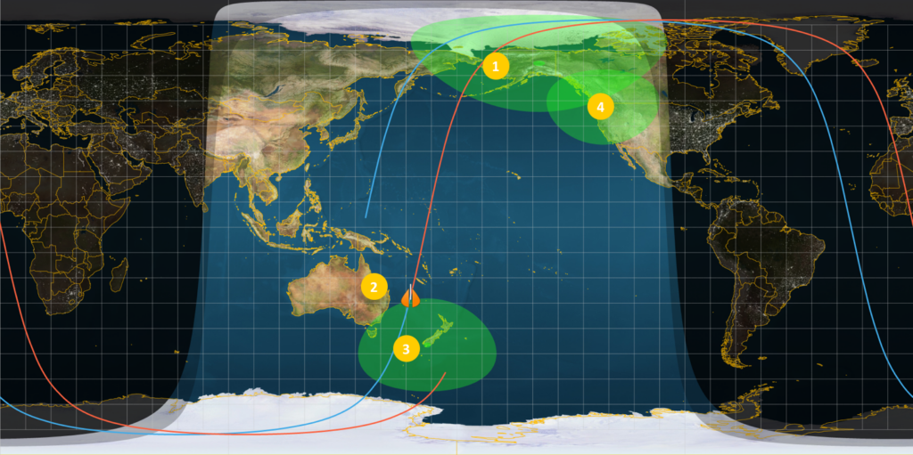
It’s been over three weeks since we launched Pathfinder-1, and by all accounts the mission has been a great success. The satellite and ground station operations have been rock solid, meeting our every expectation (more here on that.) In addition, we have moved into imaging mode and are calibrating the various spacecraft sensors.
A core value of BlackSky is to provide high quality imagery on demand, meaning we can collect it in a matter of minutes or hours, instead of days or weeks. To prove we could deliver on this vision at scale for our customers, we have been conducting demonstrations that showcase the power of the architecture. This entails creating a full systems loop of tasking, collecting, downloading and processing an image in a very short time frame which ultimately requires having a flexible and agile architecture for updating and tasking satellites.
Our First Imaging Demonstration:
Our goal was to prove our constellation could deliver images people want, when they need them. Well, how does 40 minutes sound — from tasking the spacecraft to viewing an image on screen? That’s what we demonstrated in our very first week of operations.
We’re continuing to refine the process and make adjustments but here’s how it worked just a couple days after launch:
- Pathfinder-1 was descending from over the Arctic towards our Fairbanks ground station (#1 in the image above) and we uploaded a mission script via our UHF antenna.
- The spacecraft then continued down over the open Pacific Ocean towards our imaging target in Australia: Brisbane.
- As it approached the coast of Australia, Pathfinder-1 slewed hard right and imaged Brisbane at an off-nadir look angle of 28 deg (#2 in the image).
- Pathfinder-1 then immediately slewed hard left to a similar off-nadir look angle of >20 deg to point at our New Zealand antenna (#3 above) and downloaded the image via our high gain S-/X-band communications system. It was aggressive, especially only 4 days and 19 hours after launch. But our little spacecraft delivered!
- The data file was automatically relayed to our Network Operations Center in Seattle (#4 above) and processed. The six person operations team managing all of these activities viewed the picture less than 5 minutes after it was taken over Australia! This timeline includes the time to capture it, process it on the spacecraft, downlink it to New Zealand, transfer back to Seattle, run through our image processing chain and out to a laptop. Further, the round trip time from tasking the spacecraft to viewing the image was less than 40 minutes.
The team at Spaceflight Industries built the whole stack – the ground station, the ground station software, the spacecraft and its software, and managed all of these remote ground stations. To say I’m proud of our accomplishments on this mission is an understatement.
This maneuver and the rapid time from tasking to collection and dissemination validates the vision of the BlackSky constellation. We are now working diligently on the image processing chain. Getting the images calibrated for optimal resolution is well underway so stay tuned for our first official image!