The unprecedented arrival of China’s most advanced fighter jets in Tibet is just one example of how the Chinese military’s continued expansion along India’s contested northern border raises tensions in a decades-long standoff high atop the Himalayas. With the ability to monitor the most important national security and economic locations and events at scale, BlackSky recently provided a revealing look into how China is asserting its military posture in this vast, mountainous region.
Published in the Hindustan Times, BlackSky’s rare, time-diverse satellite images and AI-driven analytics show the first presence of Chinese J-20 stealth fighters parked at a Tibetan airfield, advanced artillery and defensive infrastructure north of Pangong Lake and a winding network of roads giving China access across Bhutan’s disputed Doklam plateau. These images were captured as recently as May 31.
The region’s latest developments fuel long-standing disagreements over competing territorial claims that led to the 1962 China-India war. The still unresolved conflict resulted in a 3,380km (2,100 miles) contested border where the nuclear-armed countries collectively maintain an estimated 100,000 troops. Occasional violent skirmishes between the two militaries, the most recent of which occurred in 2022, have caused deaths on both sides. The unforgiving terrain, ranging in elevation from 3,600 to 6,400m (12,000 to 21,000 feet), and extreme cold temperatures, reaching minus 40 C in winter, make security a unique challenge.
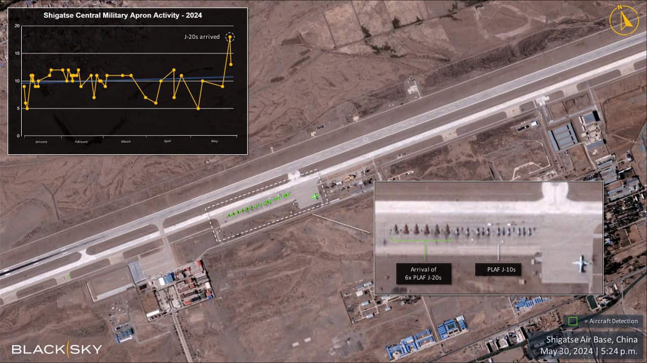
Tibet’s Shigatse Air Base
BlackSky imagery and automated detection identified six Chinese Chengdu J-20 stealth fighters parked adjacent to eight Chengdu J-10 jets on the central apron at Tibet’s Shigatse Air Base on May 30. The base is less than 150km from India’s northern border in Sikkim. Introduced in 2017, the J-20 is a dual engine, multirole fighter featuring low radar observability and precision strike capabilities designed for air superiority.
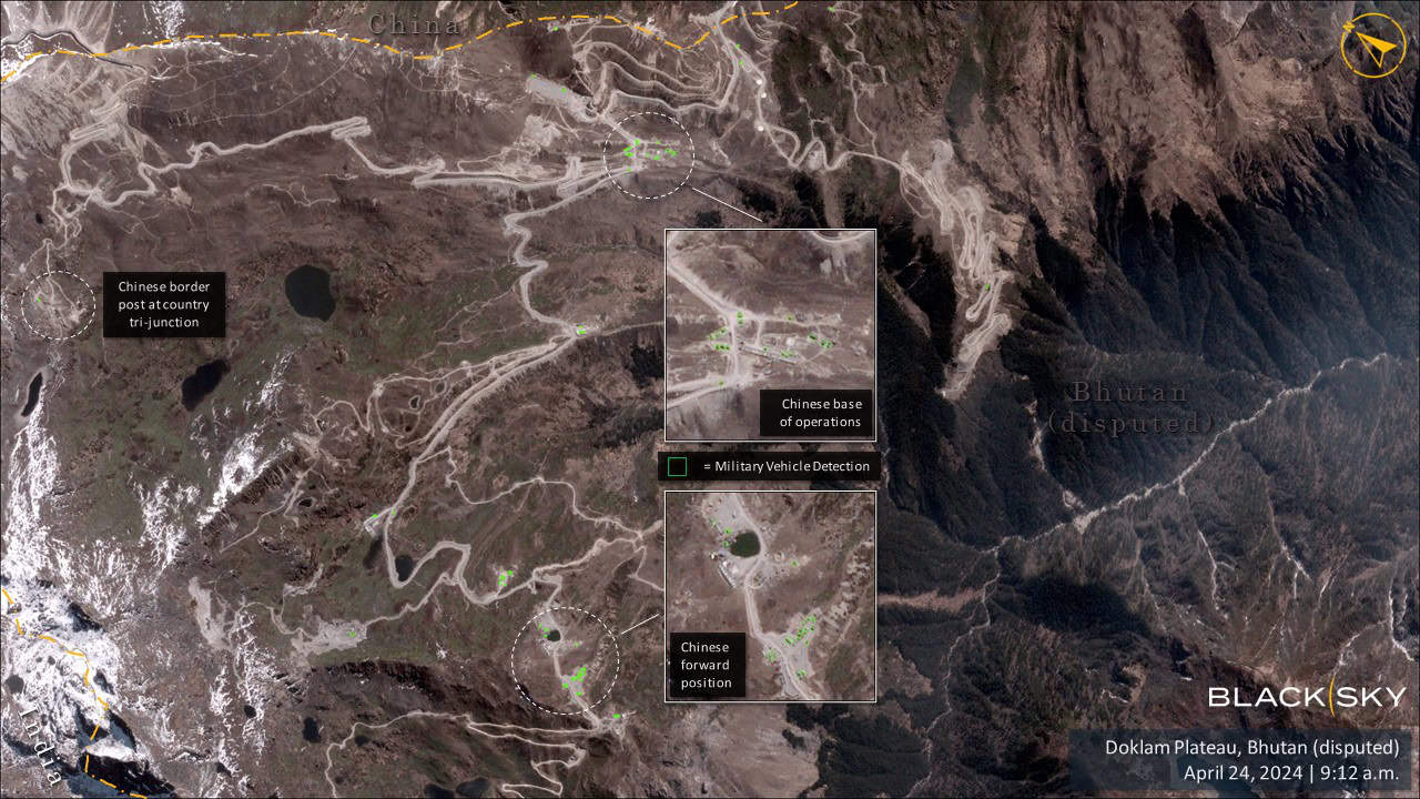
Bhutan’s Doklam Plateau

China maintains an elaborate network of roads connecting military infrastructure across the Doklam plateau in territory dually claimed by Bhutan that also borders northern India. Military vehicles detected by BlackSky’s automated analytics are positioned at various locations along the plateau, including China’s tri-junction border post, base of operations and forward position. In 2017, Chinese and Indian troops engaged in a 72-day standoff over China’s Doklam road construction.
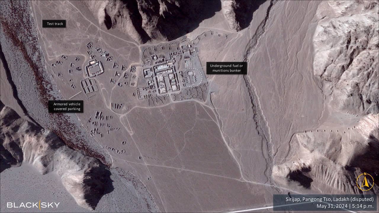
Sirijap, Pangong Tso, Ladakh

Nestled among the mountains along the northern shore of Pangong lake in the disputed Indo-Chinese border region of Ladakh, China’s Sirijap military complex hosts an expanse of armored vehicle storage facilities, test ranges and fuel and munitions storage buildings. Sirijap’s current state of development features artillery and other defensive positions reinforced by large berms and connected by a wide-reaching network of roads and trenches that are not visible on publicly available mapping applications. The Sirijap complex is located 126 km southeast of the Galwan Valley, the site of a lethal 2020 skirmish between Indian and Chinese soldiers.
The Hindustan Times quotes an unnamed former Indian Army commander on the military rationale for China’s construction of underground facilities.
“In today’s battlefield, everything can be pinpointed using satellites or aerial surveillance platforms. We have no such underground shelters on our side. Tunneling is the only way out to create better defences,” he said. “Without underground shelters, weapons and stores are sitting ducks for air strikes with precision-guided munitions. The Chinese are pioneers in tunneling activities and no hi-tech is required for these structures, just civil engineering skills and funds. Otherwise, we have to invest in more air defence equipment,” he added.
This collection showcases the power of BlackSky’s real-time monitoring of multiple sites over an entire region, delivering actionable insights from dynamic change at scale to enhance situational awareness.
Ready to learn how BlackSky’s can give you critical foresight into your missions? Start a conversation with us.